CONTEXT
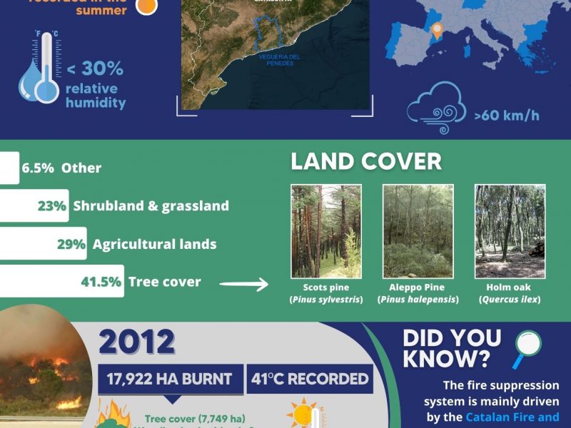
Catalonia is a Mediterranean region of approximately 32,000 km2 located in North Eastern Spain. This region is very densely populated. With 232 inhabitants per km2 in 2016, it is only surpassed by four Italian regions within the European regions of similar size.
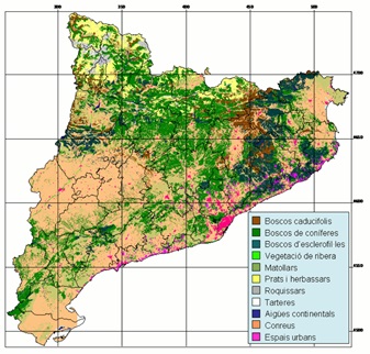
Catalonia is also the third region of Europe in terms of forest surface. Indeed, up to 60% of its territory is covered by forestlands, ranging across both woodlands and shrublands. This factor, together with fire-prone weather conditions governing its summers, makes Catalonia an extremely vulnerable region to wildfires.
Fires have decreased in the last 20 years n number and area, but they are still posing difficulties to fire suppression bodies with unknown and extreme behaviors. The Catalan Living Lab will also apply some of its FIRE-RES activities in smaller counties where wildfire risk management is a challenge.
FIRE MANAGEMENT IN CATALONIA
The territory where the Living Lab in Catalonia situates is under an unique governmental unit.
In Catalonia, the competences on wildfire prevention and suppression are mainly led by the regional Government of Catalonia. In particular, fire management is under the responsibility of:
- The Department of Climate Action, Food and Rural Agenda, that oversees the actions related to nature conservation, forest management and agriculture
- The Department of the Interior, that deal with fire management through the GRAF unit, Civil Protection and Rural Agents.
However, many other agencies, NGOs, associations or entities are also impacting wildfire management in some of its facets. Total fire suppression is the main policy in its management. However, fire has been also used as a management tool for the last 20 years at small stand scale.

CHALLENGES
- To understand Extreme Wildfires’ behaviours witnessed in recent wildfires
- To provide new tools to support decision making during extreme wildfires
- To enhance protected areas’ resilience to wildfires
- To provide new tools to WUI management and enhance its protection and reduce its exposure
- To include wildfire risk management into urban and forest planning
- To improve the communication with citizenships, media and other agencies during emergencies
- To increase awareness and preparedness among general population
- To make forest prevention actions economically feasible
- To make new insurance products that can make a shift in self-protection measures
INNOVATION ACTIONS
Emergency, Risk Mapping and Sustainable Fire Management Models
IA 1.1. Piloting an adapted Forest Fire Potential Polygons methodology to improve decision making on EW
IA 1.2. Testing key inputs for atmospheric data analysis using new knowledge and expertise on EWE
IA 1.3. Piloting early-warning indicators of EWEs incorporating fire-weather and vegetation conditions
IA 1.4. Integrated fire management model: bases, demonstration and piloting activities
Ecosystem Conservation and Landscape design
IA 1.5. Demonstration of innovative post-fire restoration and adaptation strategies
IA 2.1. Improving data acquisition for landscape design based on novel remote sensing methods
IA 2.2. Scheduling and implementing novel management practices
IA 2.3. Defining recommendations for improving security on WUI at multiple scales
IA 2.4. Optimizing landscape configuration and fire management policies to minimize expected losses from EWE
IA 2.5. Designing strategic networks of managed areas to improve suppression efforts against EWE
IA 2.6. Designing post-fire restoration strategies
IA 2.7. Landscape design strategies, using tactical planning methods
IA 2.8. Trade-off ES assessment of fire-resilient landscape design
Governance, Society, Communication and Risk Awareness
IA 4.1. Fire forums
IA 4.2. Testing a new methodology for risk communication to improve WUI homeowners’ culture of risk for insurance products against EWE
IA 4.5. Testing regional-level policy clinics for inclusive and coherent firesmart risk governance
IA 4.6. Piloting a fire-wise planning platform and conceptualization tool
IA 4.8 Demonstrating strategies and tools for smart communication to citizens
Advanced Technology Solutions - Support Tools for Integrated Fire Management
IA 5.2. Demonstration of real-time EWE simulation and smoke spread based on coupled fire-atmosphere approaches using of HR weather data
IA 5.3. Advanced vegetation characterization based on Earth Observation data fusion and Artificial Intelligence over forestland ecosystems
IA 5.5. Testing of vertical atmospheric structure models based on satellite constellation in EWE
IA 5.6. Prototyping HAPS (High Altitude Pseudo Satellites) contribution to Europe’s resilience against EWE
IA 5.7. Quantifying impacts of exposure to air pollutants from wildfires
IA 5.8. Prototyping and testing innovative tools for EW ICS training certificates
IA 5.9. Tools for international collaboration through shared operational information for specialized stakeholders
IA 5.10. Development of a Pan-European system to define management priorities to mitigate fire impact
Factsheets
A set of factsheets was produced by forestWISE to interactively complement the information available on the Living Lab.
PARTNERS
{{ group }}
{{ object.name }}
{{ object.name }}
{{ object.subheader }}
{{ icon.replace(/^icon_/, '') }}
{{ label }}
Contact

Pau Brunet
- Forest Science and Technology Centre of Catalonia
- pau.brunet@ctfc.cat

